Turning Android Phone into GIS Data Collection Device
For a project at Janaagraha we need to collect location data. The process needs to be as simple and cost effective as possible. General GPS data collectors are expensive and doesn’t make sense for us to own those single purpose devices. Hence we started looking at mobile phones. We wanted something that can collect the data offline with maps support. Of course Android turned out to be the best bet.
Here are the two mapping applications which we will be using:
- Supports GPX, KML (include styles) and LOC files.
- Works with multiple mapping platforms (needs to be online for certain maps like Google Maps, Bing Maps)
- Works with offline maps. The app itself can download the maps for a defined area. The downloaded maps can be shared with other devices. Also supports MBT maps.
- If you are running a map server, you can add your own custom online maps
- Can work completely in offline mode for data collection
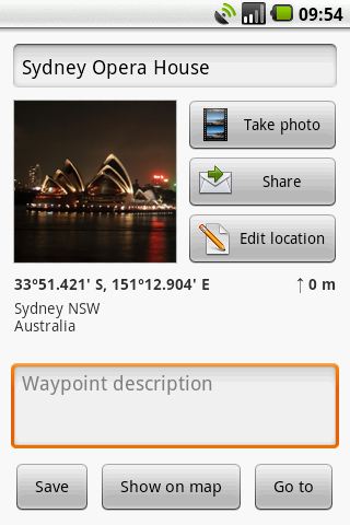
- Can’t add custom forms for data collection. The std one can collect Name, Description, Picture, Location, Altitude, Street Address, Category
- Can do standard GPS logging for trips
- Add ons are available
- Both free and paid versions can be used. Available in the market
- Can collect GPS data in KML and GPX format.
- Works with multiple mapping platforms (needs to be online for certain maps like Google Maps, Bing Maps)
- Works with offline maps. Use Mobile Atlas Creator to download maps or MAPC2MAPC to convert maps from other formats
- Can work completely in offline mode for data collection
- Can’t add custom forms for data collection. The std one can collect Title, Description, Picture, Location
- UI is clean and easy
- Can do standard GPS logging for trips
- Both free and paid versions can be used. Available in the market

We plan to use OSM as the mapping platform for collecting data since it is free and legally allows us to download maps.
There are many Android mobile applications available for extensive data collection like OpenDataKit and UNICEF’s Rapid Android. But since the above applications worked well in my POC studies, I didn’t dig deep into others. Let me know if you have tried anything like this.


Hi, allow me to make a plug for pcMapper (see website). It does much the same as described above + the DB version let’s you import/export ESRI shapefiles and define customized input forms.
hi
especially the import/export got ESRI shape file is much apreciated.
plz can u update us…
We are building a data collection app for the US department of Agriculture. The technology will allow you to create your own forms in order to collect any type of data a smartphone or tablet can handle. I think this might be what you are looking for.
Please reach out to me if you would like more information.
George
multigrano@gmail.com
Sure. I would love to see what that app does. Is there a page online?
Hello George,
My name is Paul Richardson and I work for a small municipality and am in the water dept. The City wanted to look into buying a GPS unit to be able to shoot all of our fire hydrants and water shut off valves and then download them onto a map of the city. Our water map was done by an outside agency in ESRI but only shows the streets and water lines themselves. We do not own the ESRI program and the City will not pay the $1500 for the software. I read an article that said we could use a android phone and take pictures of the hydrants, water valves, etc.. and then download those pictures (with GPS coordinates) onto our map.
I forgot to mention, we recently downloaded the Quantum GIS software (freeware) and were told that we could import our ESRI map into QGIS and then save it there and later download Photos with GPS coordinates onto that map. Could you please share any info that would help me to accomplish this or make comments on a better way to do what we are trying to do. Thank you, Paul R.
Hello Paul,
I will have to refer you to my head code writer. I believe we may have the solution for you!
Feel free to email me directly at george@gisit.com
My number is 970-490-1878
Best regards,
George
hi paul,
as I avid user of arcgis and QGIS,
I can certainly guaranty that QGIS can do many tasks as in ARCGIS, and in some cases it works at par.
QGIS…simply go for it, as plenty of resources are available are on net.
Paul,
George here in Fort Collins. We spoke last year about our data collection app. I’ve been looking for your contact and couldn’t find it.
Please email me at george@multigrain.com or george@gisit.com
Best,
George
970-490-1878
Hi, We are developing an android mobile phone into GIS data collection device as our project. Can you help us by replying certain suggestion
Go for Open data kit .
Hi, seems you have got answer of what I am looking for. I am about to start GIS data collection for the availability of improved community water points in the great lake area (Lake Victoria – East Africa). indeed I want to use my Samsung Galax Tab Ver. 7.0 for the exercise. Please which application should I use to design forms that can accomodate a 2 pages survey questionnaire. I don’t like to use any paper work during this asignment as it is very expensive to hire data entry clerks as well as to spend extra time for data entry.
Go for Open data kit .
Go for “Mappt” its simple and fast. Its mainly designed for Tablet which have Operating System: Android 4.2 (Jelly Bean) and the application is also user friendly both amateurs and professional can work with it.
pls let me know how to load shapefiles in tablets / mobile.
I would like to have sample of scripts