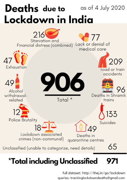
Thejesh GN Blog

2

Book: An Atheist with Gandhi

It’s an interesting book to read. Written by Goparaju Ramachandra Rao nicknamed Gora about his experience of living at Sevagram and his conversations around atheism with Gandhi. It’s interesting because Gandhi is a super-believer and Gora is an atheist. Gora is an interesting personality. He along with his wife were the founders of...

0

Book: Anarchism and Other Essays

A web spiral on Labor day celebrations in India landed me on a Wikipedia page of a well known anarchist and feminist of her day. Though I was very uncomfortable 1 with some of her methods, her views on many things are very interesting and dare I say very relevant today. As a...

Political Map of India 5

They want to take away maps they never gave us

For anyone familiar with DataMeet, a community of data enthusiasts1, you would be aware that the discussion can be rather stilted. Even though the list is dedicated to all types of data, geospatial data seems to be the main topic. There are over 700 topics related to geospatial data, out of 1600. That...

Asus Zenphone Max, I wish this had come to market before my trip. 0

Gadget: Zenfone Max the Travelers Phone

The biggest pain w.r.t phone while traveling is network and battery. I got a new phone for the last year’s epic drive, just for the trip. I paid about 10k and it was a bad phone. It would restart all the time, couldn’t focus etc. or let me just say it was disaster....

6

Book: How to Lie with Statistics

In an era where every fight online is fought with numbers, this 50-year-old book should be made a compulsory college reading. Stats and graphs are part every news-hour show and part of every political discourse now. But every bit of number is taken as fact instead of being questioned. This is where Darrell...

Chennai Flood Maps 1

Everything India’s Geospatial Regulation Bill will kill if it is passed

On April 26, India launched its own satellite-based navigation system called the IRNSS, short for Indian Regional Navigation Satellite System. The objective: to provide accurate — better than 20 metres — location information to users in India as well as the region extending 1,500 km from its boundaries. When the IRNSS-1G — the...