Tagged: OpenStreetMap

OSM Tubro Query for Pet friendly places in Bengaluru 1

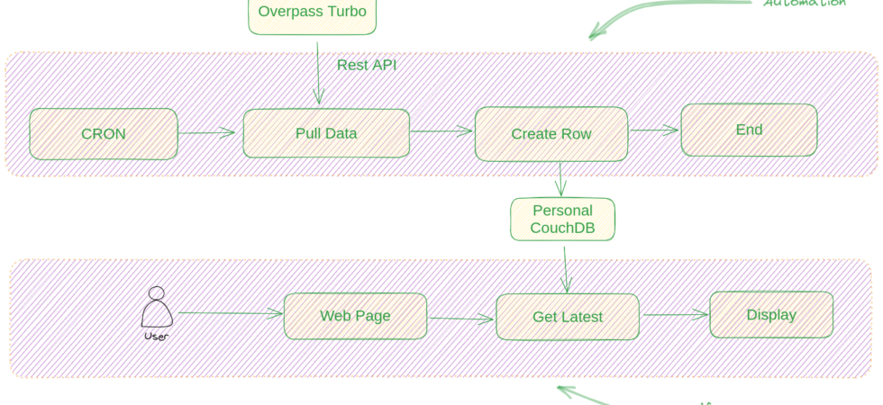
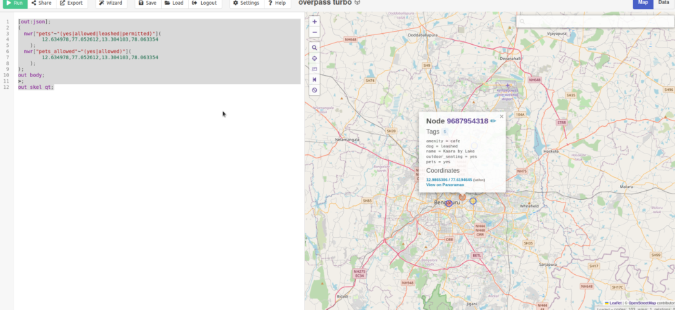
Mapping Pet Friendly Places in Bengaluru on OpenStreetMap

I have started mapping pet-friendly places in and around Bengaluru. I am considering the newer areas like Devanahalli, Hosakote, Nelamangala, Anekal, etc. Hence, the area I am mapping is bigger than the city of Bengaluru.  For mapping pet-friendly places, there are two competing tags. pets and pets_allowed. Given that Pets is used a lot, I am...

SIB Leaderboard Design 1

Building Surveillance in Bangalore leaderboard using Budibase and CouchDB

I wanted to convert the script from the blog post Who is mapping Surveillance in Bengaluru into a simple web app. I could have written a simple javascript and HTML code to call the overpass-turbo API for data and charted using javascript. All in the browser. But there was a much better option with less code.

Who is mapping Surveillance in Bengaluru 1

Who is mapping Surveillance in Bengaluru

Mapping CCTV cameras ( Surveillance ) is a community effort on OSM. You can credit OSM contributors as defined on this page when you use the data. But personally I wanted to see who are the folks who are contributing to this data. So I went to Overpass Turbo and ran this query to get...

2

Data: Public, Private and Beyond

The Bachchao Project hosted the “Data: Public, Private and Beyond” from 12th to 15th May 2023 at Panjim, Goa. It’s an Art on Tech exhibition inspired by The Glass Room. I wanted to go but couldn’t due to personal and work reasons.

I showcased Surveillance in the Bengaluru project to attract more contributors to mapping Surveillance in Bengaluru or other cities.

Osm Go! PWA Screenshot 0

Linked List: Three Android Apps to Efficiently Contribute to OpenStreetMap

From a browser, I moved to contributing using GPS Logger or OSMAnd. That made my workflow a lot easier, but these apps are not for editing maps but for regular map use. They are okay if you are not mapping frequently or in mass. So editing flow in these apps is not seamless. Hence I continued to explore other options.

0

How to Download Surveillance in Bengaluru Data

Everything we map goes directly to OpenStreetMap. The data on OpenStreetMap is available for free under ODBL. The easiest way to download Surveillance in Bengaluru data is from Overpass Turbo. I have written some queries below that you can use on Overpass Turbo to get the data. I also have a demo video for you.